

» Destination's informations
Back to map �South Carolina
 South Carolina is a state in the United States that borders Georgia to the south and North Carolina to the north. Originally part of the Province of Carolina, the Province of South Carolina was one of the 13 colonies that declared independence from the British Crown during the American Revolution. The colony was originally named by King Charles II of England in honor of his father Charles I, as Carolus is Latin for Charles. South Carolina was the first state to vote to secede from the Union and was the founding state of the Confederate States of America. According to an estimate by the United States Census Bureau, the state's population in 2009 was 4,561,242 and ranked 24th among the U.S. states.
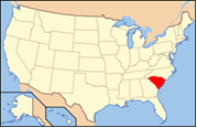 Also known as : The Palmetto State
Capital : Columbia
Largest city : Columbia
Population : 4 479 800
Abbreviation : SC
Main cities : Columbia, Charleston, Spartanburg, Greenville, Myrtle Beach, Anderson, Florence

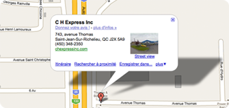
 743, Avenue Thomas